


fond du broc ste Roseline

Michel DUBOIS
User
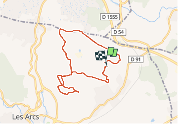

Length
8.8 km

Max alt
220 m

Uphill gradient
186 m
Km-Effort
11.3 km

Min alt
137 m

Downhill gradient
186 m
Boucle
Yes
Creation date :
2025-04-07 07:01:40.683
Updated on :
2025-04-07 10:10:31.988
2h25
Difficulty : Very easy

FREE GPS app for hiking
 SityTrail
IGN / Geographical institutes
SityTrail Plus
The world is yours!
About
Trail Walking of 8.8 km to be discovered at Provence-Alpes-Côte d'Azur, Var, Les Arcs-sur-Argens. This trail is proposed by Michel DUBOIS.
Positioning
Country:
France
Region :
Provence-Alpes-Côte d'Azur
Department/Province :
Var
Municipality :
Les Arcs-sur-Argens
Location:
Unknown
Start:(Dec)
Start:(UTM)
298343 ; 4816732 (32T) N.
Comments